 |
The Greek Age of Bronze
Trojan War |
 |
The Trojan war tales, handed down through the centuries by Homer and other Greek and Latin bards and poets, have excited the collective imagination representing the most worldwide famous myth.
Which historical reality is behind these tales? A conflict or a series of local wars in a period and location which can be archaeological related with the Homeric Troy really happened?
Comparing some documents and sources as well as analyzing the esametric rules and linguistic form of the Iliad, it is now possible to make a reasonable reconstruction of a series of facts which, when placed in a specific historical context, can provide us with some answers reducing the possibilities. |
| THE ILIAD COMPOSITION IS OLDER THAN HOMER |
| One of the question matter of discussion between the scholars is about the origin of the Homeric poems. Which material inspired a poet to produce a work of such great quality? Where did it come from? It has seemed implausible that the poet should have completely invented it. Have the bards of the eighth century BC. take reference and gave continuity to works and oral compositions originated many centuries before them? |
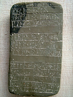
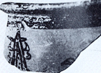
Linear B tablet from Pylos |
Since the British architect Michael Ventris deciphered the Linear B tablets in 1959 found in several Achaeans settlements in Greek mainland and Crete, it was clear that this language used by the Helladic population of the late bronze age (1600-1100 BC.) was an early form of Greek-language. The Linear B was thus an archaic Greek- 500 years older than Homer- and written in rather abbreviation form, but Greek nevertheless (*1).
Furthermore Ventris' early deciphering and interpretation of the Linear B was reviewed and elaborated by others linguistic scholars whose research eventually demonstrated that the Linear B was actually a Greek-language
The importance of these discoveries leads to the fact that the bearers of the Achaean culture were ethnically identical with those of the revived Greek culture of the eight century BC. Comparing the linguistic form of the Linear B and the later Greek form of the Homer's time the most obvious difference is the loss of the digamma "W". In the old form the "W" is still written, and thus at that time pronounced; in the later form it has been lost, meaning that by this time it was no longer pronounced.
As well explained by Prof. Joachim Latacz in his book (*2) this fact leads to a very interesting discovery about the origin of the Homeric poems. |
Homer's verse is written in hexameter lines. The basis of this versification lies in the difference between long and short syllables. The hexameter (six-measure) comprises the six-time-repeated dactylic foot [- ~ ~], which may be replaced by a spondee [- -]. This means that a hexameter can be formed only by a series of six feet in the form " one long syllable followed by two short syllables" [- ~ ~] or of feet in which the two short syllables are replaced by a single long syllable [- -]. It is therefore never possible to use a measure consisting for example of one long syllable, one short syllable, and one long syllable [- ~ -] or of three short syllables [~ ~ ~].
But in Homeric text there are several hexameter which exhibit precisely these impossible measures, thus violating the hexameter rule. What can have happened here? Any Homer scholar know that Homer does not usually make mistakes!
The answer was found by the British scholar Richard Bentley he established that in all these cases the apparent error could be accounted by the loss of digamma "W"; a Greek bard of the eighth century BC. like Homer, who did not pronounce the sound "W" and therefore did not write it, composed his lines as if he did pronounce and write it. This means, firt of all, that the poet of our Iliad cannot have been the inventor of the genre in which he writes. If he had been the "W" would have played absolutely no role. Thus the poet inherited the genre from his predecessors who practised the genre at a time when the "W" was still pronounced. This takes us back to the Achaeans Greek when , thanks to Ventris' decipherment, we know that the "W" was written in Linear B and therefore pronounced at that time. |
There are also some archaeological evidences that the Homer's poems had origin in the Achaean period. The poems mentioned several un-doubtful elements coming from the Late Helladic time like the boar tusked helmet (see the pages dedicate to the helmets), full body shields (see the page dedicated to the body shields), abundance of gold elements, huge walls well constructed defending the cities, important rule of the women in the palace style society. Furthermore the continuous list of people, objects, number of dead, and the elaborate structure of the ships catalogue shows a striking resemblance to the bureaucratic and administrative record-keeping in the Achaean palace cultures as we encountered in the Linear B tablets.
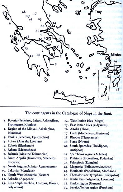
In the famous ships catalogue (*3) twenty-nine contingents of attackers are listed, each forming a geographical and political entity. Each of these shows the same structure: (1) name of the region and enumeration of the places furnishing men for the expedition (2) names of the respective commanders, (3) the number of the ships and the crew number for each. This list embraces 267 hexameters and record not less than 178 geographical names which have been largely retained until today, so that in this list of troop contingents we can recognize Greece.
Through the catalog of the ships we can now try to determine the time when the tales of Troy was originated. So far not one of the 178 geographical names in the catalogue of ships has been proved to be fictitious. Moreover the majority of these location are knows to us from sources outside Homer. An important point is also that the area cover by these names enclosed almost the entire area of Greece, though its political division and area of settlements in some cases do not correspond to the one of eighth century BC.
The Greeks of the historical time were unable to locate almost one quarter of the places named in the catalogue, which can only mean that, by the eighth century, these places were no longer populated. |
 |
The most likely solution of the problem is to assume that these place-names and places indeed no longer existed in the Homeric time (or later), yet had once existed and were large enough to provide crew for a war expedition. In the nature of things, this time could not have been the as call " Dark Age" (1000-900 BC.) but only that of the Achaean age. The modern Archaeology give us new confirmations about this assumption being some places named in the catalogue abandoned before the Dorian occupation (about 1000 BC.) and after and never resettled have been now discovered like for instance the Lakedaimon near Sparta or Eutresis and Elenion mentioned in a Linear B tablet found in the 1990s near Thebes.
Furthermore we now know that also elements generally considered prerogative of the early iron-age like the cremation of the dead peoples (*3a), the utilization of iron weaponry or the proto-hoplite tactics were also know by the Acheans of the Late Helladic time as well as in Anatolian areas. Recent accurate analysis of the Rituals described in the Iliad have also demonstrate their connection with the Bronze Age ritual in Anatolia (*3b). All these elements give us a reasonably evidence of the period when the Trojan war tales had their origin, but of course they can't prove alone the historicity of the war and the existence of a city called Ilios. |
Troy area in the late 13th Century BC |
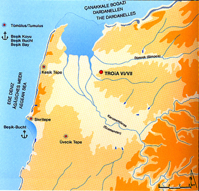
Since the ancient Greek time the site of Troy located in the north-west of Anatolia close to the narrow straits known as Dardanelles (the Greeks called this straits "the Helles-pontos") was treated as a site of national triumph and pilgrimage. Alexander the Great paid homage to the shrine when he crossed into Asia in 334 BC. By Roman times Julius Caesar visited the Sigeum promontory and the semi-derelict remains of Ilion. Under the Caesars a new phase of construction began the site was intensively visited and honored by Greeks and Romans.
Even if the settlement fell into disuse, in the sixth century AD. it continued to be honored. Many travelers accounts (Cyriac of Ancona, Mehmett II, Elizabeth's ambassador John Sanderson etc...) survive from the Middle Ages and the story of Troy never lost its appeal. Even if the precise topographical location of Ilios was apparently almost forgotten by the academic world, with the birth of the modern archaeology the site of Ilios was again excavated and rediscovered by several archaeologists like Frank Calvert, Heinrich Schliemann, Wilhelm Doerpfeld, Carl Blegen and recently by Manfred Korfmann and Ernst Pernicka with the team of the Troia Project. |
| The settlement consisting of nine stratied cities built in some cases one over the ruins of the other (see also the page dedicated to Troy). Two of these stratifications, named as Troy VIh and Troy VIi (formerly called Troy VIIa) dated between 1300 and 1180 BC., seem to be compatible with the city described in the Homeric poems. It was a well-built Bronze Age Anatolian style citadel with large streets, strong walls and towers. The fortifications around the royal citadel consist of gently sloping walls of well-cut masonry with vertical offsets and massive towers (cf. Homer's "angle of the lofty walls", and "strong towered Ilios"). |
| The recent excavations leads by Manfred Korfmann had disclosed a possible existence of a lower town in the south-west area from the upper citadel excavated by the first archaeologists. With this lower town the total area of the city covered about 40 hectares, with an estimated population of 10,000 inhabitants. By using new technique like geo-magnetic imagine (a form of X-ray photography which made it possible to obtain an extensive picture of the lower strata without disturbing the surface strata) it has been possible to determinate the position of two defensive ditches the first was about 400 meters south of the citadel, which probably enclosed the total area of Troy VI, the second a hundred meters beyond the first, at the very bottom of the hill. Even if further excavations and evidences would be necessary to precisely identify the structure of this lower town, some remains in the north-east bastion of the citadel seem to be the meeting point between the bastions of the upper citadel and the defensive wall around the lower town. Additional evidences of the lower town and the defensive ditch have been found by the team of professor Ernst Pernicka. His team uncovered a trench 1.4 Km long, 4 meter wide and 2 meters deep. Furthermore trace of a southern gate, southeastern gate and southwestern gate have been also found. Parts of two ceramic "pithoi" were also found in the trench near the edge of the lower town, suggesting that houses in the lower town stretched to the trench, another indication that Troy's lower town was fully inhabited .
| 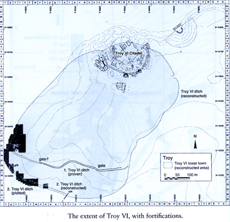 |
| Based on this discoveries Troy VI was more than a citadel-a kind of cliff-top eyrie with the function of a "Knight's castle" but a large Anatolian royal seat and trading centre, located in a strategically area to control the sea-trade routes of the Dardanelles between the Mediterranean areas and the Black Sea. |
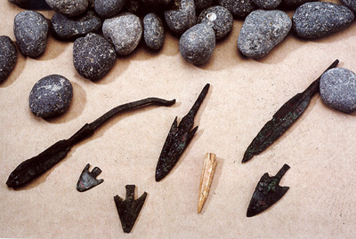
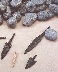
Spearheads and arrowheads from Troy VIh/ VIi strata |
Around 1300 - 1270 BC. Troy VIh was severely damaged by an earthquake, as is evident from the large vertical cracks in the surviving fortification walls. Nevertheless, Doerpfeld found evidence for fire or fires at various places in the destruction level of Troy VIh. Likewise Korfmann' s excavation has also revealed signs of war, namely a thick charcoal layer dated roughly to 1250 BC. as well as slingshots, bronze spearheads and arrowheads scattered in the debris and lodged in the fortification walls.
The remains of houses of Troy VIh and the citadel fortifications, were hastily repaired and reused and many new ones built in former empty spaces. There is no cultural and political break and change of population between Troy VIh and Troy VIi even if a considerable drop in quality for the new domestic structures is evident. The new houses are smaller and cramped, while the rebuilt ones are partitioned. All the evidence points to an increase in population, and the number of large storage-vessels (pithoi) set deeply into the ground, inside the citadel could represent a sign that the Trojans of this period did not feel secure and thus had adopted a "siege mentality". |
Troy VIi was sacked and destructed by fire in a date between 1220 and 1180 BC (more likely 1210 BC).
Human skeletons in the burned rubbish as well as arrowheads and slingshots have been found.
The destruction by fire, the traces of bodies, the weaponry- put them together with the overcrowded conditions and the storage jars, give the image of a threatened community desperately laying in supplies to withstand a siege, and than the evidence of their final destruction. Was this the archaeological proof that the Trojan War had actually taken place? The citadel discovered in the Hisarlik hill was actually the ancient Ilios and the Homeric Troy? |
| POSSIBLE IDENTIFICATION OF THE HOMERIC ILIOS IN THE HITTITE TABLETS AND LUWIAN INSCRIPTIONS(*3c) |
Remarkable discoveries in central Turkey have lead to the decipherment of the Hittite language and have revealed the existence of a great empire which stretched from the Aegean to the Euphrates valley at the precisely the time when more likely the Trojan War occurred. In the Hittite archives we have thus real historical texts to interpret: diplomatic letters, treaties, annals and royal autobiographies where the relationship between the Hittite empire and their neighbors (places and populations) are often described. Several Hittite tables make reference to the city or the area of Wilusa one time also associated with the name Taruwisa (*4). This city was located in the Assuwa country in the North western area of Anatolia. This area was involved in some conflict with the under expansion Hittite empire. The Hittite king Tudhaliya I (Late 15th-Mid 14th BC) defeated some of the local population which were absorbed into the Hittite kingdom, while other countries remain independent even if under the Hittite political influence.
For the above mentioned phonetic laws of Greek the name Ilios was before Homer Wilios which is phonetically comparable with the Hittite form Wilusa. Furthermore, even if the name Taruwisa can't be fully phonetically associated with the Greek Troia the similitude is at least reasonable. The city of Wilusa under the Hittite King Muwattalli II (about 1290-1272 BC) become what the Hittite called "soldier servant" that is a Hittite vassal state with military responsibilities and with a promise of Hittite military protection in return. (the Hittite tablets also mentioned Wilusa troops/chariots fighting in the Qadesh battle of 1274 BC).
Following the Hittite tablets description and comparing them with some archaeological evidences it is now possible to connect Wilusa with the city excavated in the Hisarlik hill traditionally identified as the Homeric Troy. |
| 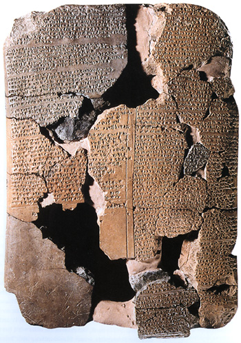
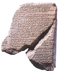
Hittite tablet from Hattusas (Bogazkoy) |
One of the most clear evidence was found years ago by Professor David Hawkins of the School of Oriental and African Studies in London. In the Karabel pass which takes the road from Ephesus to Sardis over the Imolus range, not far from the modern Turkish city of Izmir, there's an ancient sculpture of an armed human figure cut into the rock.
However, no one knew what it meant, because until Hawkins' breakthrough, no-one had been able to decipher the inscription associated with the sculpture. Hawkins' translation identified the human figure as the King of a powerful western country called Mira.
The sculpture probably marked Mira's northern frontier with another kingdom called the Seha River Land. We now know that this kingdom extended north from the Karabel pass towards the northwest corner of Anatolia. When taken in conjunction with a letter, this new information helped scholars to locate the kingdom of Wilusa.
The letter was written by a king of the Seha River Land called Manapa-Tarhunda to his Hittite overlord. It describes how a notorious local trouble makers called Piyamaradu (*5) has attacked Wilusa. The Hittite King orders Manapa-Tarhunda to drive Piyamaradu out, but he fails dismally and the Hittites send out an expeditionary force to do the job themselves. Before reaching Wilusa, the Hittite force arrives first in the Seha River Land and from there march directly into Wilusa.
This leads to the inescapable conclusion that there is only one possible location for Wilusa - in the far Northwest corner of Turkey, the precise location of the site of Troy. It seems likely that Wilusa and Troy are one and the same.
Furthermore in the Hittite treat with Wilusa of Muwattalli II (about 1290-1272 BC) an underground watercourse is mentioned (The Troy watercourse is also mentioned by Homer and it has been actually found by Manfred Korfman excavation), the Wilusa deity is Appalliunas (The Apollo deity protector of Homeric Troy?) and the Wilusa governor or King is Alaksandu (which recalls the Greek name Alexandros the other name of Paris). Also the name Paris seems to be the Hittite/Luwian name Pariya (or Priya) as well as the Priam's name too may be Pariya-muwa (or Priya-muwa) composed from a place-name or adverb plus-muwa "strong" even if these names are given without further context.
|
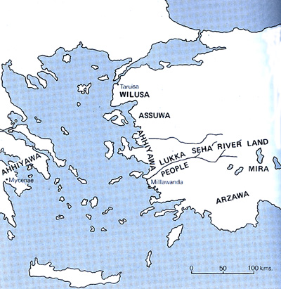
Western Anatolian based on Hittite tablets |
There are several Hittite/Luwian diplomatic documents showing references with the city or the area of Wilusa:
1) Wilusija (later called Wilusa) appeared in the Hittite text under King Tudhaliya I (Late 15th-Mid 14th BC) when this King defeated a coalition of 22 Luwian countries and cities located in the Assuwa, Arzawa, Seha river and Haballa areas. In this damaged annals also the name Taruwisa is mentioned.
2) On a letter dated around 1290-1272 BC by King Manapa-Tarhunda of Seha river land (*6) to a not specified Hittite King (more likely Muwattalli II) Wilusa and the surrounding areas are mentioned because the mercenary called Piyamaradu had depose the governor of Wilusa Kukkunni and he is also moving to attack the island of Lazpas (Lesbos) but the Hittite army moved in the area defeating the mercenary. In this letter Wilusa is described as a city located up to north of the land under Manapa-Tarhunda control, thus in the Troad area.
3) Also during the Kingdom of the Hittite King Muwattalli II (about 1290-1272 BC) a tablet describes the alliance treat between the Hittite empire and the new governor or King of Wilusa named Alaksandu. In this document the Wilusa deity Appalliunas (Apollo ?) and the underground watercourse of the land of Wilusa (actually found by archaeological excavation) are mentioned. |
4) In the Tawalagawa letter the Hittite King Hattusili III (about 1267-1237 BC) wrote to the Great King of Ahhiyawa (Achaeans) about his concern for the activity of Piyamaradu who in collusion with the Ahhiyawa king's brother Tawagalawa (which seems correspond to the Greek name of Eteocles) based in Milawanda (Miletus) are making raids in Lycia. Hattusili II is thus obligate to send his army in the Milawanda area, and Piyamaradu with Tawagalawa have fled overseas. In this letter a past hostile situation in the Wilusa area is also mentioned.
5) Another reference to Wilusa said that the deposed governor of the area Walmu (successor of Alaksandu) was refugee to the Myra King but Tudhalija IV order him to return back to Wilusa.
6) The last mention of Wilusa in the Hittite text is in a letter from Suppiluliuma II (after 1207 BC) to the King of Myra about some contrast for the throne of Wilusa.
7) An interesting reference about Wilusa it has been also found in another Hittite table with religion locutions about the holly city of Istanuwa. In that area was recite a song which starts: AH-HA-TA-TA A-LA-TI A-U-I-EN-TA U-I-LU-SA-TI "When steep they comes wilusa". Unfortunately the text is incomplete but if the song makes reference to something happened in Wilusa more likely it was a glorious military event. But since the city of Istanuwa wouldn't precious located or other elements will be discover, this possible "Wilusiad" will remain just a speculative hypothesis.
8)In the Luwian hieroglyphic inscription from Edremit is mentioned the great prince of Mira and Wilusa Muksas (i.e. the ruler of Wilusa on behalf of great king Kupantakuruntas II of Mira) with the regions and place-names belonging to his realm. The enumeration of the various place of the real runs clockwise strating with the islands of Lesbos (including its main towns Antissa, Methymna and Mitylene), Imbros, Lemnos and Tenedos. In the west, continues with the place-names Abidos, Arisbe, Perkote, Pityeia and Parion. In the northeast, in order to end with Gargara, Adramyttion and the town of mount Leleges in the south.
The overlap with the realm of Seha (Lesbos, Adramyttion and mount Leleges) as recorded by the inscription from Yazilitas can be explained by the fact that the latter inscription is dedicated by the son of Kupantakuruntas III, Walwamuwas, and therefore dates from a later period as the Edremit inscription. At this point in time the realm of Seha may have been expanded at the expense of the Troad as its king Walwamuwas had risen to the status of great king.
9) In the Luwian hieroglyphic Inscription of Beykoey 2(*6a) is mentioned Kupantakuruntas, great king of Mira On behalf of Walmus, king of Wilusa...this for him town. In Mira (the enemy)destroyed the town of a servant. Great king Mashittas (supported) Wilusa (if the enemy) will destroy this town...Towns of the government (and) not (directly of the government (total 25): Awisana, Parnasan, Troy, Taparwisa, Kirsusa...not (directly): the land of Harna, Purusuwa, Suruta...
In another part of the text is mentioned that this stele is placed also (for/in) Mira. The prince (or) palace official (who) will covet (it) for himself: may you guard Wilusa (like) the great king (of) Mira (did)!...The script continue mentioning that (There are in sum) 6 king(s): the king (of) Wilusa, the king (of) Hapalla, the king (of) Urawalwas'land (=Seha), and the king (of) Assuwa, and the great king (of) Mira...In another part of the inscription is also mentioned Muksus, great prince in the land(s) and town(s of) Mira and Wilusa.
|
It is now clear that in the Bronze Age the area traditionally identify as the Homeric Troy was know to the Hittites as Wilusa and the Greeks as Wilios. Moreover, in the "land of Wilusa" at the end of the fifteenth century BC, the Hittites knew an area called Taruwisa, which can scarcely be distinguished from the Greek Troia. This city was an important political-economical Luwian center and that it was, since about 1290 to 1215 BC, allied with the near Hittite empire. We know from the Hittite tablets and archaeological excavation that war actions, destructions and diplomatic crisis occurred in that area. The city that Homer's Iliad tells of is therefore certainly a historical reality, and in the Bronze Age it lay in precisely that area of north-west of Anatolia where the tradition places it.
But were the Achaeans involved in these events? Were the Homeric Achai(w)oi mentioned in some historical documents and were they involved in warfare activity in the western Anatolian area during the late Bronze Age? |
| 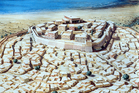
Reconstruction of Troy VIh/VIi (Wilusa of the Hittite text)
Copyright by Christoph Haussner Munich |
| THE ACHAEANS IN THE HITTITE TABLETS. |
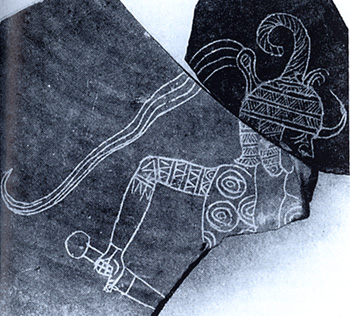
Possible representation of Ahhiyawa warrior on Hittite pottery (about 1350 BC) |
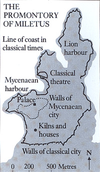
In Several Hittite texts the population of Ahhiyawa, which occurred at an early date as the name of a country, is mentioned. Not only does this name bear an obvious phonetic resemblance to the Achai(w)oi found in the Iliad and the A-KA-WI-JA-DE on Linear B tablet C 914 from Knossos "...a hecatomb of cattle is sent to akhaiwian.." which seems to be a unique Cretan reference to the mainland Greeks (*7). But this word also, considered geographically and politically, seems to point to the people we know as "Greeks". In the so-called Taswagalawa letter the Hittite King Hattusili II (about 1265-1240 BC) consistency addresses the King of Ahhiyawa formally, using the style " my brother". The significance of this is that the King of Ahhiyawa is placed on the same level as the Kings of Egypt, Babylon, Assuria and the Hittite King himself (*8). Furthermore it is clear that, at least at the time the letter was written, the Ahhiyawa were a political and military force to be reckoned with. Some expressions like "By ship" and "crossing" suggested that the Ahhiyawa were located overseas most likely to the west of Asia Minor. Based on some Hittite tablets the Ahhiyawa operational center in Anatolia was located in the city of Millawanda following the Hittite army trip of King Hattusili II to reach the area and based on some other places mentioned in association with Millawanda, that can be located in the inter-land of Miletus, it is clear that the geographical location of Millawanda correspond to the city of Miletus (*9). |
| In Miletus an Achaean style citadel as well as pottery, and other Mycenaean elements have been actually discovered. Based on the above mentioned Hittite documents this settlement was attacked and sacked around 1315 BC by Mursili II and by Hattusili II around 1250 BC. Evidences of destruction in the Achaean Miletus are in fact also attested by the archaeological excavations. In these periods the Achaeans settlements in the Anatolian coast and the relevant diplomatic relationship with the Hittite empire seems to be lead by the Achaean city of Thebes. In the letter of Hattusili II the name of the Ahhiyawa's Great King brother is Tawagalawa which has been interpreted by some scholars as the Hittite version of the Achaean name E-te-wo-ke-le-we or E-te-wo-ke-we-ios. These two occurrences of the name in the Pylos tablets seems to supply an evolutionary link between Tawagalawa and this early version of Eteokles who is traditionally related with the Achaean kingdoms of Orchomenos and Thebes. Another evidence is in a letter from the Great King of ahhiyawa to Hittite King Hattusili II. In this document (written in Hittite but the linguistic features of the text confirm that the writer spoke Greek, rather than Hittite, as his mother tongue) the Ahhiyawa King call himself heir of Kagamuna. This name has been interpreted by some scholar as the Hittite version of the name Kadmos who is traditionally the founder of the Achaean city of Thebes. This is archaeological reasonable being the city of Thebes, before its destruction (about 1250 BC) (*10), comparable in size and political/military power with Mycenae. |
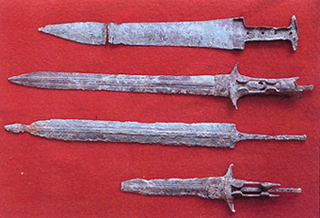
Bronze Achaean and Hittite swords from the Achaean acropolis of Miletus dated 13th Century BC |
 |
Miletus is associated with Thebes also in the archive Linear b tablets which contain repeated reference to a certain "Miletian"; this man was involved in ritual sacrifices and occupied, possibly, a certain position in the Theban palace.
In this Achaean pottery fragment from Miletus dated LH IIIB2 (about 1250 BC) a typic Hittite style high helmet or pillar seems to be represented. |
 |
 |
Only two Mycenaean chariot vases are known from Anatolia, and they are not directly associated with other chariot-related archaeological material. At Miletus, one fragment of a LHIII:A2–IIIB amphoroid chariot krater comes from the Athena Temple area in a lower level along a Mycenaean defense wall, and two bits were found in a chamber tomb of the Degirmentepe necropolis. This necropolis shows a strong Achaean influence, but the shape of the houses and the pottery used do not allow us to attribute any nationality to inhabitants.
Two fragments of Mycenaean chariot kraters come from Troy VI. Sherd VI.E.21 comes from the Earthquake area and the other one was found on the surface somewhere along the southern side of the Trojan Citadel (*16). According to stylistic criteria, they might derive from the same vase, but the reported places of discovery make it uncertain.
Neither fragment has a clear archaeological context.
In Anataolia, Mycenaean ceramics were found at 26 sites, most of them being located along the western coast of the peninsula. The only Hittite sites where Mycenaean ceramics were found are Mahat Höyük and Beycesultan. There, less than 10 sherds have been excavated, none of which were chariot kraters. It is possible that the Anatolian coastal regions differed greatly from Hatti, where no chariot kraters have been found. For example, it seems that Miletus was more closely associated with Aegean traditions. |
| On a Mycenaean pottery dated XIV-XIII Century BC found in Besiktepe in the Troad area a figure seems also wearing a possible scale corselet. |
 |
 |
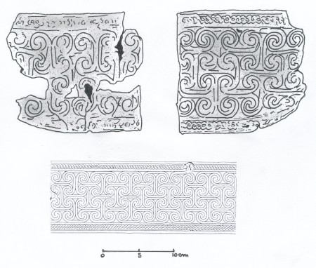 |
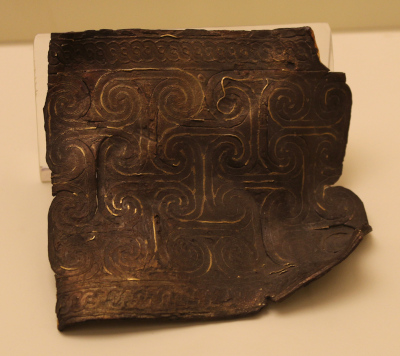
A very interesting pieces of what wery likely was an Aegean bronze war belt dated aroun 1300 BC has been found in the Anatolian settlement of Buyukkale near Bogazkoy.
The belt is composed by three layers the two external are in bronze while the middle one is made in silver. The layers are bended to each other on the edge. Inside the grooves of the external decorations gold threads are inserted.The decoration shows very close similarity with some attested in Mycenae and Crete. |
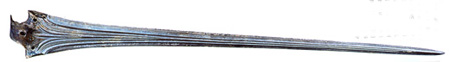
| It has been suggested that this inscribed bronze sword dated around 1370 BC found at Hattušas Anatolian, is a Mycenaean B Type sword. The present independent investigation of the sword indicates that it may well be a variant of an Aegean B type sword, but might reflect Achaean influence rather than outright manufacture. |
 |
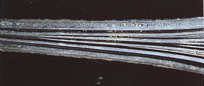 |
The inscription on the blade is dedicated to the god of the storm by the Hittite king Tuthalia II after the conquest of the Assuwa land. A variety of evidence suggests that the sword must be interpreted in the light of events occurring some two hundred years prior the Homeric Trojan war. As recorded in contemporary Hittite documents It is possible that Ahhiyawa involvement in the Assuwa rebellion in 1400-1375 BC (see also the page dedicated to the swords). |
There are several Hittite documents in which Ahhiyawa appears:
1) The earliest is an Oracle Report (AHT 22). It dates late 15th-early 14th century BC under the reign of Tudhaliya I/II. In this tablet the name Ahhiya is associated with an enemy ruler of them.
2) The second one is the so-called Indictment of Madduwata (AHT 3). It dates late 15th-early 14th century BC under the reign of Arnuwanda I, even if many of the events narrated in this text had taken place under the preceding king Tudhaliya I/II, and recounts Hittite dealing with a certain Madduwata, forced to flee his country by Attarissiya (Forrer sought to identify this name with the Achaean king Atreus) whom the Hittites called Man of Ahhiya(wa). Madduwata was installed as a Hittite vassal ruler somewhere in southwestern Anatolian; however, he proved to be an ungrateful and overambitious person, who caused serious trouble for his overlord by attacking Hittite posesions in what appears to have been the area of classical Lycia and Caria. Later he even invaded Cyprus in alliance with his former enemy Attarissiya. In this table is also indicated that Attarissiya fought in the area with 100 chariots and thousand infranty and that one of his officer was killed.
3) In another tablet known as Ten-Years Annals of Mursili II (AHT 1A) dated late 14th century BC, it is mentioned that a man called Piyama-Kurunta son of the Arzawan king Uhha-ziti come out from the sea, and he entered (into exile) with the King of Ahhiyawa.
4) The next reference which is correlated with the previous tablet comes from the Ten-Years Annals of Mursili II (AHT 1B). He conquered the country of Arzawa, which lay in the area of classical Lydia, with its capital Apasa (classical Ephesus). Relying on the King of Ahhiyawa, it engaged in hostilities against the Hittites and incited the land of Millawanda to rebellion, but was defeated and its prince probably handed over to the Hittites by Ahhiyawa King.
5) Other references of Ahhiyawa are present in the Oracle Report (AHT 20) dated late 14th-early 13th century BC (Mursili II). In this report the rituals prescribed include summoning the god of Ahhiyawa and the god of Lazpa, and determining the appropriate ritual to be used for them. We do not know which particular gods of Ahhiyawa and Lazpa were fetched.
6) In the so-called Prayer of Mursili II/Muwattalli II/Urhi-Teshshup(?) (AHT 12) dated late 14th-middle 13th century BC the fragmentary text seems to constitute a self-justification of the speaker, certainly a Hittite King, before the gods. In this prayer the King said that while his father was still alive , and because (s)he became hostile to his mother, his father dispatched him/her to the Land of Ahhiyawa, beside the sea.
7) The survived portion of letter (AHT 9), dated Mid 14th-13th century BC from a king of Hatti (perhaps Mursili II or Hattusili III to a king of Ahhiyawa), appears to deal with someone (Piyamaradu ?) or something , brought from Ahhiyawa to another place . There is reference to a legal dispute, and to a tablet perhaps connected with it that the writer has separately dispatched to his addressee.
8) In the letter (AHT 7), from Manapa-Tarhunta of the Seha River Land to a King of Hatti (probably Muwattalli II) dated early 13th century BC, the main topic is the defection of a group of skilled Hittite craftsmen, dyers, to a ruler by name . Although Ahhiyawa is not mentioned in the preserved lines, the missive definitely belongs to this corpus, as demonstrated by the appearance of Piyamaradu, Wilusa, and Lazpa (Lesbos).
9) In the letter (AHT 6) dated Early-to mid 13th century BC from a King of Ahhiyawa to Hittite King (probably Muwattalli II) (written in Hittite but the linguistic features of the text confirm that the writer spoke Greek, rather than Hittite, as his mother tongue)(*10a) the King of Ahhiyawa cites a previous letter from his correspondent. This means that by the time this letter was written a regular exchange of correspondence was established between Hattusa and Ahhiyawa. The letter deals with the matter of the islands which originally belonged to Assuwa. The Hitite King asserted in his message that these islands belonged to him. The King of Ahhiyawa objects that an ancestor of his received the islands from the King of Assuwa. These islands were very likely Lemnos, Imbros, and/or Samothrace. Furthermore the Ahhiyawa king explains that a forebear of his had given his daughter in marriage to the then King of Assuwa (which after the chronology of Kings know to us must have been in the fifteenth century) and that consequently the islands had come into possession of Ahhiyawa. The mentioned forebear is Kagamuna who has been interpreted by some scholars as the possible Hittite name for Kadmos(*10b) who as above mentioned is inseparably linked with Thebes(*11)
10) Probably the most important, and certainly the longest, Hittite text regarding Ahhiyawa is the so-called Tawagalawa letter (AHT 4) dated Mid-13th century BC. It is the letter of the Hittite King Hattusili III (about 1267-1237 BC), to the Great King of Ahhiyawa, whose name is unfortunately not preserved. The letter is named after the first person mentioned in it, which is Tawagalawa, brother of the Ahhiyawa King. A more suitable label, however, would be "the Piyamaradu letter" because it is a complaint of the Hittite King to his fellow sovereign in Ahhiyawa about the depredations of Piyamaradu on Hittite territory, apparently committed with the tacit approval of the Ahhiyawa King. The most prominent feature of the letter is the apologetic and conciliatory tone used by the Hittite King to address the King of Ahhiyawa, probably a proof that the country of the latter was a respectable military power beyond Hittite reach. All this compatible with the facts known to us about the Achaeans of that age. |
 |
 |
11) In a letter (AHT 8) dated Mid-13th century BC from a Hittite official to a King of Hatti (Hattusili III ?) there is a passage refers to the dispatch of gifts to Egypt and to the King of Ahhiyawa, within the context of the conduct of diplomatic relations between the Hittite King and his counterparts in Egypt and Ahhiyawa. It is clear that at the time of the letter's composition, the Hittite King who was its recipient enjoyed peaceful relations with both Egypt and Ahhiyawa. This makes it likely that the man in question was Hattusili III, and that the letter is probably to be dated to the period shortly before or in the aftermath of the treaty which he concluded with the pharaoh Ramesses II in 1259 BC .
12) In another letter (AHT 15) dated 13th century BC from a King of Hatti (Hattusili III?) to another Great King is mentioned the King of Ahhiyawa and Piyamaradu, who long acted as an agent of Ahhiyawan interests in the west.
13) In the votive prayer (AHT 26), dated Mid-13th century BC, of Poduhepa? (wife of Hattusili III) there is no reference to Ahhiyawa but its references to Piyamaradu, who had been supported by the Ahhiyawan King in his anti-Hittite enterprises, indicates the Hittite regime's continuing concern over his activities.
14) In the "Boundary" list (AHT 18) dated Mid-to late 13th century BC (Reign of Hattusili III or Tudhaliya IV) there are references to the lands of Tarhuntassa, Mira and Ahhiyawa and other kingdoms of western and southern Anatolia. That Ahhiyawan-controlled territory in western Anatolia bordered on the kingdom of Mira can be inferred from the fact that a King or Kings of Ahhiyawa exercised for a time sovereignty over the land of Millawanda (Miletus), which lay directly south of Mira.
15) In the Extract from a letter (AHT 14) dated Mid-to late 13th century BC, from a King of Hatti (Tudhaliya IV?) concerning Urhi-Teshshup, it is mentioned that following Urhi-Teshshup' removal from the Hittite throne by his uncle Hattusili III, the deposed King was assigned a place of banishment in the Nuhashshi Lands in Syria. He was determined, however, to get his throne back, and in his bid to do so sought the support of both foreign kings and his former vassal rulers. In a passage of the leter it seems that Urhi-Teshshup had also made approaches to the king of Ahhiyawa. This suggests that Ahhiyawa still had a significant presence in the Near Eastern world, at least in the westernmost part of it.
16) In the letter (AHT 11) dated Late-13th century BC, Offenses of the Seha River Land (royal edict of Tudhaliya IV?) a personal involvement of the Great King of Ahhiyawa to support the rebellion of the Seha River Land. It may well be that Ahhiyawan support for the rebellion finally induced Tudhaliya IV to force a military showdown with the Ahhiyawan regime-an action that may have resulted in the elimination of Ahhiyawa's sovereignty over Milawata, and the end of an effective Ahhiyawan political and military presence anywhere in western Anatolia. |
17) In the survived fragments of a letter known as "Milawata Letter"(AHT 5) dated Late-13th century BC from a king of Hatti (probably Tudhaliya IV) to a western Anatolia ruler (Tarkasnawa, king of Mira?) the Ahhiyawa are not mentioned but there is reference to several individuals and political entities deeply involved with them. The rogue Piyamaradu, the land of Wilusa, and the city of Milawata. The reinstallation of Walmu as King of Wilusa leads us to conclude that the Great King here was probably one of the successors of Muwattali II, in whose reign Wilusa was governed by Alaksandu. The most likely author of the dispatch is Tudhaliya IV.
18) In the Treaty (AHT 2) between Tudhaliya IV and Shaushga-muwa king of Amurru dated Late-13th century BC there is a reference to the king of Ahhiyawa in the list of foreign rulers whom Tudhaliya IV considers his equlas. Unsurprisingly, the rulers of Egypt, Babylonia, and Assyria are included in the list. And originaly the list also contained the King of Ahhiyawa-the name subsequently being erased. A possible conclusion is that the Ahhiyawan King had indeed enjoyed the status of one of the Great Kings of the Late Bronze Age world, at least in Hittite diplomatic terminology, but had recently lost this status.(*12)
19) The two letters (AHT 27A and B) dated Late-13th century BC respectively from Suppiluliuma II (1207-? BC) and Penti-Sharruma, a Hittite official, to Ammurapi king of Ugarit, deals about an unacceptable delay of shipment of (copper) ingots from Ugarit to Ahhiyawans currently present in the land of Lukka. This is the last known reference to Ahhiyawa in Late Bronze Age sources. By this time the Ahhiyawan kingdom referred to in earlier Hittite text had lost its Anatolian territories. The Hiyawa-men were no doubt private groups of adventurers who remained n the Anatolian mainland in the wake of the loss of Ahhiyawan sovereignty in the region or came their living as freebooters or as mercenaries in a foreign king's hire.
20) The Ahhiyawa are also mentioned in other very fragmentary tablets (AHT 10, 13, 16, 17, 19, 21, 23, 24, 25) dated durign the 13th century BC which are too fragmentary for translation or comments.
21) In the inscription (AHT 28) dated Mid-to late 8th century BC of Warika king of (Ah)Hiyawa this king calls his kingdom Hiyawa. The kingdom was located in southeastern Anatolia, in the region called Cilicia in classical sources. Some scholars have noted that Hiyawa is simply an aphaeresized form of Ahhiyawa, and it is possible that the name reflects a migration of populations of Ahhiyawan origin from western Anatolia or the Aegean world to Cilicia at the beginning of Iron Age. If commonly assumed link between the Hittite name Ahhiyawa and the Greek Achaia is valid, then the migration theory would appear to tie in with the claim by Greek historian Herodotus that the Cilicians were originally known as Hypachaians ("Sub-Achaians"). |
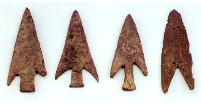
Achaean arrowheads from Troy VIh/VIi strata |
Citadel under siege on the silver rhytom from shaft grave IV at Mycenae dated around 1550-1500 BC |
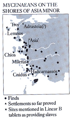
Unfortunately no similar diplomatic style documents were produced by the Achaean palace administration or at least no evidences have been so far attested. Nevertheless on some of the linear B tables from Pylos seem provide evidence of female slaves coming from the eastern Aegean. The women were either captured during seaborne raids, or brought from slave traders. The fact they are usually mentioned with their children but not with men implies the familiar raiding pattern of predatory war-bands, when the men are killed and the women carried off. These groups of women are recorder doing menial tasks such as grinding grain, carding flax and spinning wool. Their ration quotas suggest that they were numbered in the hundreds (about 700 women with their 400 girls and 300 boys who..."belong to them"). Many are distinguished by ethnic adjectives, probably denoting the places they came from, and though some of these are still not understood, several of the women come from eastern Aegean island or the western seaboard of Anatolia- Knidos, Miletos, Lemnos, Halikarnassos, Chios and AS-WI-JA which seems to be related the Assuwa (Lydia) of the Hittite tablets. Recorded on one tablet from Pylos (PY Ep 705.6) there is even the enigmatic name TO-RO-JA (woman from Troy?). Other possible references of a woman or a man from Troy are also attested on one tablet from Knossos and one from Thebes. These descriptions often use the term LA-WI-AI-AI "captives" which is the same word used by Homer to describe women seized by Achilles at Lyrnessos during a predatory foray south of Troy (*13). |
| It was now clear from the Hittite tablets and from several archaeological evidences that the Achaeans of the 14th and 13th centuries BC (the heyday of their civilization) were largely involved in trade, diplomatic and armed foray along the shores and islands of the western Anatolian. Based on these elements is it thus possible to make some reasonable hypothesis about the historicity of the Trojan war also taking into account the traditional Myth? |
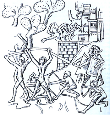
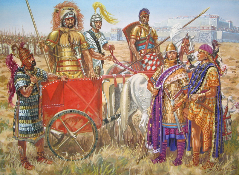 Hypothetical reconstruction of Ahhiyawa army lead by Tawagalawa with his mercenary Piyamaradu under negotiation with Wilusa governor (Alaksandu?) and Hittite ambassador in the land of Wilusa. This plate reconstructed by A. Salimbeti and R. D'Amato and drawn by G. Rava is published by Osprey in the warrior serie n. 153 BRONZE AGE GREEK WARRIOR 1600-1100 BC Hypothetical reconstruction of Ahhiyawa army lead by Tawagalawa with his mercenary Piyamaradu under negotiation with Wilusa governor (Alaksandu?) and Hittite ambassador in the land of Wilusa. This plate reconstructed by A. Salimbeti and R. D'Amato and drawn by G. Rava is published by Osprey in the warrior serie n. 153 BRONZE AGE GREEK WARRIOR 1600-1100 BC |
| TROJAN WAR LANDSCAPE AND ACHAEANS CAMP |
Combining an interest in the classics with expertise in the sedimentary geology that defines coastlines, John C. Kraft, H. Fletcher Brown (*13a) Professor of Geology University of Delaware researcher has discovered that Homer’s Iliad presents an accurate account of the geography of ancient Troy, information that may end a centuries long debate.
Kraft writes in the February 2003 issue of the journal Geology, which is published by the Geological Society of America, that the area’s sedimentology and geomorphology do indeed complement the features described in Homer’s Iliad. "The reality of Homer’s description of place, event and topography correlated with geologic investigation helps show that the Iliad is not just a legend but regularly consistent with paleogeograhic reconstruction," concluded the research team, which also included George Rapp of the University of Minnesota, Ilhan Kayan of Ege University in Izmir,Turkey, and classical scholar John V. Luce of Trinity College in Dublin, Ireland. Kraft has been studying the ancient coastlines of the eastern Mediterranean Sea for more than two decades and has always been interested in the classics, and particularly in their descriptions of geography. However, some years ago he met Luce, a noted classicist who Kraft said "understands the Iliad backwards and forwards.". He asked him if in his reading he had encountered incidents that indicated in any way topography.
|
| 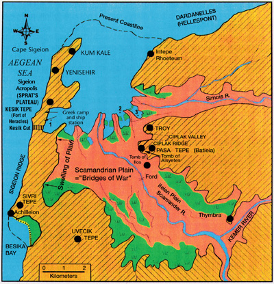
A map showing Professor Kraft discoveries |
| After discussions of the basics of geography and geology as related to archaeological settings, Luce began to uncover "dozens and dozens of such incidents," Kraft said.
Kraft said archaeologists working around Hissarlik in western Turkey have found evidence of a city of the right age to be Troy. One problem with pinpointing the exact location of the Achaeans camp in relation to the city is that the landscape has changed drastically over thousands of years because of siltation caused by the Scamander (now called the Kara Menderes) and Simois (Dumrek) rivers.
Researchers now know that Troy once stood alongside a large bay, a portion of which was already filled by silt by the time of Homer, Kraft said, adding that today the bay is completely filled.
Using borings to determine the geomorphic environment, the researchers were able to develop maps of the changing coastline and found that the landscape at the time of the Homeric account of the Trojan War, about 1250-1180 B.C., does indeed match descriptions in the Iliad and in Strabo’s later "Geography".
It appears that from the epic tale Strabo correctly calculated at about four kilometers the distance of Troy from the camp and ship station manned by the invading Achaeans. He also spoke of blind mouth marshes and saltwater lagoons and marshes, which Kraft said are "very precise determinants of the shape of the coastline and ancient landscape at the time of the Iliad."
From the Iliad itself, Kraft’s paper notes several descriptions, including the terrain covered by the line of defense established by the Trojans and their allies as described to the Greeks by the captured Trojan spy Dolon.
"I will answer your questions truly and exactly. On the wings towards the sea are Carians, Paionians with their crooked bows, Leleges, Kaukones and devine Pelasgians. On the wing towards Thymbra lie Lycians, proud Mysians, and Phrygian and Maeonian charioteers," Dolon said.
And from another passage, "Outside the town…there is a high mound…which men call Thorn Hill (Batieia)…It was here that the Trojans and their allies now formed up in battle order."
Kraft said that shows the Trojan line of defense extended from the sea in front of Troy southeastward, covering the possibility that the Greeks would attack anywhere along the Scamander Plain.
He said it is apparent from the writings that the Achaeans camp and ships station were in clear sight of one another, and cited two passages that describe the encampment and the ship station:
"Whenever he looked toward the Trojan plain, he wondered at the many watch fires blazing before Ilios, at the sound of flutes and pipes, and at the murmuring from the host of men."
And, "The ships had been beached on the shore of the surging sea well away from the fighting. They dragged the first ones inland and built a wall at their sterns. For the beach, though broad, could not contain all the ships, and the force was cramped. So they ranged them in rows, and filled as the long mouth of the shore between the enclosing headlands."
Kraft noted that in antiquity, the Greek commentator Aristarchus compared the rows of beached ships to "seats in a theater" and "rungs on a ladder."
The Iliad also describes the Kesik Cut, a great wall and ditch proposed by the ancient Greek warrior Nestor as a protective device "to hold back horses and fighting men so that the stout Trojan battle line may not overwhelm us."
The poem describes how horses were "brought up short on the edge of the ditch and stand whinnying in fear, unable to jump it or pass over it."
The section that tells of the battle at the Scamander Plain notes that when the Trojan line broke, many warriors "were pinned back against the deep stream with its silver eddies. In they tumbled with loud splashes, and the din resounded from the depths of the pools and from the banks on the other side. With piteous cries they swam here and there, whirled round by the current."
Such a dramatic description of a deep river with cut banks and strong currents can only fit the middle and upper stretches of the Scamander Plain before Troy, Kraft said.
Given the vivid images painted in the Iliad, Kraft said he believes the author had seen the landscape firsthand. "You can’t have really detailed descriptions of areas without having seen them." Kraft said.
|
| TROJAN WAR HYPOTHESIS
|
Let us review at this point what we learn from the Anatolian sources which may have some bearing on the Trojan war tradition.
1. Achaean Greek were closely involved in the political and military affairs of western Anatolia, particularly in the thirteenth century.
2. During this period the Hittite vassal state Wilusa was subjected to a number of military actions in which Achaeans may have been directly or indirectly involved. On one or more occasions its territory was perhaps occupied by outside troops; on one or more occasion its king was dethroned.
3. Wilusa lay in north-western Anataolian in the region of the Classical Troad.
4. In philological terms, Wilusa can be equated the Greek (W)ilios or Ilion.
5. At some point within the period of the recorded hostilities against Wilusa, Troy VIh and Troy VIi was destroyed. These levels are the best in accord with Homer's description of the citadel of Troy.
Considering these and the others above mentioned elements coming from the historical documents and the archaeological sources we can thus express a reasonable hypothesis about the Trojan war:
Since the time of the defeat of the Assuwa coalition, in the time of Tudhaliya II, Wilusa and Hattusha had regular diplomatic relations, so Wilusa managed to keep out of the conflicts between the Hittites in Arzawa and was not involved in the annihilation of the kingdom of Arzawa for hand of Mursili II. Wilusa continued to thrive and conduct regular trade with the Achaeans. The development of the city was certainly favored by the fact that the Kaska, at the beginning of the fourteenth century BC were quite active and prevented Hattusha from having a safe access to the Black Sea. Perhaps it is possible to identify traces of the Assuwa war in the southern part of the Wilusa fortress, (one of the oldest palaces of Troy VIf was devastated and many of the expensive vases of Achean origin were destroyed). But this attack was not too heavy and therefore cannot be one or the Trojan War. Perhaps it was a "private" confrontation with a commercial partner (the Achaeans?) Or a preventive action by the Hittites to restore Wilusa to order.
At the time of Suppiluliuma I the king of Wilusa was called Kukkunni, at the time of Mursili II, he replaced him on the throne with Alaksandu who was forced, after the aggression of Piyamaradu and the Ahhiyawa around 1280 BC to conclude a vassalage treaty with Muwatalli II.
Around 1285 BC Piyamaradu allied with the Ahhiyawa tried several times to grab a throne in one of the kingdoms of western Anatolia and only managed to stop in Wilusa. The king of the land of Shea (Manabatarhunta), bordering to the south, intervened to help Alaksandu and thus Piyamaradu also attacked Lazba (Lesbos) who was part of the domain of Seha. Manabatarhunta withdrew and sent a request for help to Hattusha. Muwatalli II sent troops under the command of General Gassu who together with a contingent of troops from Mira were able to defeat Piyamaradu, also devastating the land of Masa east of Wilusa, which had also taken part in the conflict. Piyamaradu with the support of the Ahhiyawa and his base-point in Milllawanda (Miletus) of which his father-in-law Atpa was regent managed to escape and continued to create problems so much that at the time of Hattusili III he was also active in Lukka in the southwest of Anatolia. The fact that the Ahhiyawas intruded in this way in the affairs of the Hittite vassals in the West area of Anatolia led to severe tensions and possibly even conflict. The object of the dispute was precisely Wilusa.
Since the 14th century BC the Achaeans under the leadership of Thebes?, Mycenae? Have in fact extended their control in several western Anatolian shores and eastern Aegean islands. In these areas their most important logistic and military centre was Miletus. From the letter of Hattusili III (about 1260 BC) it is clear how the raids of Piyamaradu and his allies Ahhiyawa continued even in that period and affected the Wilusa area so much that the Hittite king was forced to send his troops to destroy the support base of the Achaeans of Miletus.
The city of Wilusa was thus attacked and partially damaged around 1260-1250 BC (Troy VIh) also due to an earthquake that could have weakened Troy's walls and left them open for attack. This first event was probably conducted by the Achaeans together with their ally Piyamaradu. In that period the citadel of Wilusa was still a Hittite vassal state so the Achaeans were soon obligated to withdraw by the intervention of the powerful Hittite army. The diplomatic relations with the Hittite empire were interrupted (The Achaean Great King was in fact deleted in the Hittite treaty of Tudhalija III). Wilusa was not completely destroyed in fact Alaksandu continued to reign even after. There was a change only in the time of Walmu (around 1210 BC) who took refuge from the king of Mira after a revolt in Wilusa. But he too became king in Wilusa again also after this period.
The Hittite empire started to enter in crisis and the reciprocal diplomatic treaty with the city of Wilusa ended.
During the collapse of the Bronze Age society the flow of migrating populations in different Mediterranean areas in which also the Achaeans were involved, was the cause of the destruction of the Luwian city of Wilusa which was again attacked, destroyed and burned around 1200-1180 BC (destruction of Troy VIi, formerly Troy VIIa). The memories of the previous Achaeans sieges on the Wilusa land and the surrounding Anatolian areas plus its final destruction, also caused by the Achaean Sea People, take form in a poem which starts to be orally composed by the bards in this very late bronze Age sub-Mycenaean period as a memory of the heroic past time.
|
| THE TROJAN HORSE
|
| Several theories have been made about the famous Trojan horse, for some scholars it could have been a kind of war siege machine even if no evidences exist that large and elaborate siege machine were used by the Greeks of the Bronze Age. Indeed documentary evidence from Syria and Hattusa does indicate that such machines were in use as early as the 18th century BC and that they were named after animals (the wild ass or the wooden one-horned animal). An interesting and plausible theory is the one about the Trojan horse as a metaphor and a symbol of the God Poseidon (*14) who damaged Troy VIh by an earthquake. For other people the Trojan horse could be just a symbol on a city gate left unlocked by pro-Achaeans Antenor or a huge gift to some Deity left on the beach by the Achaeans for a safe home return. Many of these theories sound convincing nevertheless we can not completely exclude that a real object existed and that it played a role in tricking the Trojans into leaving their city without defenses. Thus was a real example of unconventional warfare, Bronze Age style. Probably we will never know if this object was actually a huge horse with warriors hidden inside it or just an empty statue carried inside the city as a trophy at the end of the siege. It was in fact a trick to relax the Trojans and allow one or more disguised Achaeans inside the city to light a signal fire to bring the Greeks back. |
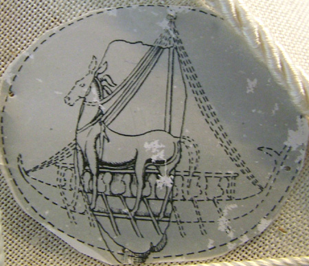
Huge horse on a cetula from Konossos dated around 1200 BC |
| In Archaeology there is an interesting seal from Knossos dated more likely in the final phase of LM III (about 1200 BC). This seal, probably used as a warranty mark for the traded goods, shows a huge Achaean style horse placed over a single mast ship with oarsmen (*15). Furthermore in a late Achaean pottery fragment which was exhibited in the Nauplion museum a huge horse surrounded by men seems also depicted, but of course the interpretation of these elements as a genuine Achaean representation of the Trojan horse, without any other evidences, is just speculative.
|
(*1) Michael Ventris-John Chadwick, Documents in Mycenaean Greek ( II edition); Cambridge University Press (1973).
|
(*2) Joachim Latacz, Troy and Homer, Towards a solution of an old mystery; Oxford University Press (2004).
|
(*3a) At Mueskebi on Halicarnassus peninsula several typical Achaeans chamber tombs and graves dated from LH IIIA-C have been found. Inside these tombs at least three cremations have been attested dated around LH IIIA, 2-B. It has been suggested that this Anatolian rite was introduced into southern Aegean via Mueskebi. For cremation burials in the Dodecanese see Mee 1998. For possible LH IIIA cremation in chamber tomb at Ialysos see Benzi 1992.
In the cemetery at Besik Tepe in the Troad dated LH IIIC inumations and several cremations have been also attested together local Achaean pottery, bronzes, sealstones and jewellery. These cremation burials have been also found at Panaztepe and Bakla Tepe and are similar to the ones already discovered by Belgen in the small Troy cemetery at Hissarlik.
Near Mycenae at Khania, E. Palaiologou has excavated a tumulus that contained urns with cremated remains (as in the burial of Patroclus in the Iliad) and finds dating to LH IIIC Middle and Late.
|
(*3b) Sarah Morris, From Kizzuwatna to Troy? Puduhepa, Piyamaradu, and Anatolian Ritual in Homer; University of California Los Angeles 2013
|
(*3c) The identification of Wilusa and Taruwisia with the Omeric Ilios and Troy has been for long time just one of the various hypothesis of the scholars majoring in the Hittite civilization and relevant tablets deciphrements. Others theories like for instance the one of Vangelis D. Pantazis (Nikaea) WILUSA RECONSIDERING THE EVIDENCE 2009, placed Wilusa in other areas of Anatolia. However the location of Wilusa in the Troad is now definitely assured by the rediscovery of the Luwian hieroglyphic inscription from Edremit. In this text the regions and place-names belonging to the realm of Muksas, great prince of Mira and Wilusa, are enumerated clockwise starting with the islands of Lesbo.
|
(*4) Taruwisa only occurs once, in the damaged annals of Tudhalija I (about 1420-1400 BC), the first Hittite King to visit this region, in a list of towns of the land of Assuwa on the west coast of Anatolia. These towns are apparently listed in geographical order starting from the border with Lukka land, and this puts Taruwisa, the last in the list, in a northery location in the Troad, in fact.
|
(*5) Piyama-radu (Piyama means gift and Radu was a good deity) was probably a Luwian price belong to the "Apta" population. He seems to be a dangerous mercenary alied with the Ahhiyawa (The Achaeans). He is mentioned in several Hittite tables associated with the reigns of Muwattali II, Hattusili III, and Tudhaliya IV.
Given that Muwattali's reign ended ca. 1272 BC and Tudhaliya's began ca. 1237 BC, Piyamaradu' career as an anti-Hittite activist in the west must have covered at least three and half decades. The longevity of his career is extraordinary enough in itself. But even more extraordinary is the fact he could for so long have so successfully defied Hittite authority, resisting all efforts by his adversaries to run him to ground-and perhaps ending his days peacefully in an island haven provided by his Ahhiyawan supporters, whose interests he served so well.
|
(*6) It is know by other documents that this region correspond to the modern Mysia.
|
(*6a) The Luwian hieroglyphic of Beykoey 2 is the longest Late Bronze Age text known to date. However some scholars some scholars like David Hawkins have expressed doubts about its authenticity. They argue that it was the product of the livery imagination of James Mellaart, who falsified them apparently out of resentment of his critics and in order to give a surge to his otherwise ruined carreer. Some other expert however considered highly unlikely that a not expert in Luwian hieroglyphic as Mellaart could be able to falsify a such long text. For these scholars no one, not even Hawkins himself, could falsify a Luwian hieroglyphic text of the lenght of Beykoey 2
|
(*7) The mainland Greeks referred to the Cretan as "Kretes" (Bennet 1999 11-30).
|
(*8) Hagenbuchner 1989: I. 45f - Kings of equal status usually address on another as ..."My brother"-.
|
|
(*9) In some place the name is Milawata suggesting an early Greek form Milwatos. In fact Millawanda/Milawata and Milwatos share the same stem, Mila-. The name, as mentioned in the foundation myth of the city, was either imported from Crete, replacing its original termination -tos with the Luwian wanda, or was an indigenous name (Milawata) pre-dating the arrival of the Cretan settlers who then used their own place-name Milwatos on the basis of the resemblance of the two appellatons.
|
(*10) As for the traditional Epigons mith Thebes was destroyed by a coalition of Achaean reigns some decades before the Trojan war. For this reason it was not mentioned between the kingdoms involved in the expetion lead by Mycenae King Agamemnon against Troy.
|
(*10a) Craig Melchert in his paper work : Mycenaean and Hittite Diplomatic Correspondence: Fact and Fiction argues that all evidence of the extant text of KUB 26.91 shows that the author (i.e, the composer of the text) was a Hittite native speaker (whose language contained Luvianisms, expected in Neo-Hittite). Contrary to the claims of Starke, there are no non-native usages in the text available to us. He seriously considered the possibility that the actual messages were conveyed between the respective capitals orally by messengers, the written text being dictated to scribes only after receipt, perhaps as per above only for use in preparing replies. Melchert thus argues that KUB 26.91 could be a Hittite translation. One possibility is that messages were conveyed in writing to the respective frontier outposts of each kingdom in its own language and script (an accompanying oral version conveyed by messenger is not excluded). Messages were then conveyed to other side orally under conditions of mutual security, where they were written down in the other language and sent on to capital.
|
(*10b) The letter in question CTH 183 refers to Kagamuna (ka-ga-mu-na-aš-za-kán), which the Anatolian scholar Frank Starke suggested was an Anatolian form of Greek Kadmos. As has been pointed out by Craig Melchert and Joshua Katz, however, this reading is untenable on grammatical grounds and must be rejected. About this letter there have been in fact multiple very tendentious attempts to identify it with names from Greek legend. 'Kadmos' is one, which requires an emendation to the Hittite text; 'Agamemnon' is another, which misinterprets the erasure before the name as an extra syllable.
|
(*11) The Greeks have always held Kadmos to be the founder of Thebes, and the royal city of Thebes was and is still caled Kadmeia.
|
(*12) If, as seems plausible, the relations of the Hittite empire were maintained with the High King of Ahhiyawa from Thebes this Achaean city just loose his power in that period.
|
(*13) Iliad XX, 193. It is also a remarkable fact that Homer names a number of islands in the eastern Aegean as homes of women taken on Achaian raids, including Lesbos, Skyros and Tenedos (Iliad: IX, 128-130, 270-272, 664-665; XI, 625-627)
|
(*13a) Kraft joined the UD faculty in 1964. He holds a bachelor’s degree in geology and mineralogy from the Pennsylvania State University and both a master’s in geology and sedimentology and a doctorate in geology and micropaleontology from the University of Minnesota.
|
(*14) For the Greek mythology Poseidon, also personified as a horse controlled, from his sea-domain, the devastating force of the earthquake. This ability to summon earthquakes earned Poseidon the epithet of "Earth Shaker".
|
(*15) Based on Homer also the Cretan king Idomeneus was one of the warriors hidden inside the wooden horse.
|
(*16) BLEGEN et al. 1953: 340, fig. 412 no. 6 and 6a.
|
|